
San Fernando ZIP Mapping Records
The San Fernando ZIP code directory needs a jurisdiction check beside every postal result. The incorporated city is compact and surrounded by the City of Los Angeles, while USPS city names are routing labels. The table separates the primary city delivery area from nearby or non-geographic ZIP uses. A ZIP match is a starting key. It is not, by itself, proof that a parcel lies inside the city or that a person lives at it.
| ZIP | Areas Covered or Relationship | Post Office | Notes |
|---|---|---|---|
| 91340 | Incorporated San Fernando and a postal delivery area that may not exactly follow the city boundary | San Fernando Post Office, 308 S Maclay Ave, San Fernando, CA 91340-9998 | Primary city ZIP; retail hours observed at inspection were Monday through Friday 10 to 5 and Saturday 10 to 1 |
| 91341 | PO-box and non-geographic mailing use associated with San Fernando boxes | San Fernando boxes; physical facility uses 91340 | Do not map as a residential neighborhood |
| 91342 | Sylmar standard ZIP touching the north and east interface | Sylmar, 13700 Foothill Blvd | Most of the area is not San Fernando; verify each parcel |
| 91345 | Mission Hills and the City of Los Angeles | Mission Hills Post Office, 10919 Sepulveda Blvd | Postal city can read San Fernando even though the address is outside the incorporated city |
| 91331 | Pacoima and the City of Los Angeles | Pacoima Post Office, 13507 Van Nuys Blvd | Adjacent false-positive warning, not a San Fernando city ZIP |
USPS geography and legal geography answer different questions. The first tells a carrier where to route mail. The second tells a researcher which city, county, or planning office holds a record. Keep the ZIP, city jurisdiction, normalized situs, and parcel AIN in separate fields from the start.
San Fernando 91340 ZIP Lookup
91340 is the primary postal code associated with the incorporated City of San Fernando, but the research does not treat it as a perfect city outline. Use the official USPS San Fernando Post Office record to confirm the delivery office and the standardized address form. The manifest capture below shows the official lookup surface used for that check.
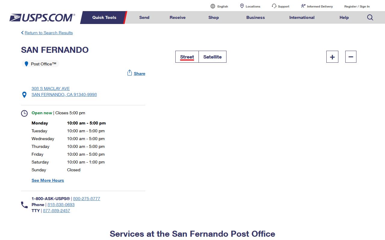
The post office record places the facility at 308 S Maclay Ave and shows retail hours of Monday through Friday 10 to 5 and Saturday 10 to 1 at the inspection date. Those hours describe a service counter, not the limits of the delivery area. A parcel with 91340 still needs city-boundary confirmation before it is called a San Fernando city property.
For a person or family-history question, retain the complete standardized address and the date of the USPS check. Then move to the county parcel key. The postal result can correct spelling and delivery form, but it cannot supply a resident roster or settle title.
91341 Is Not a Neighborhood
91341 is the important non-geographic distinction in San Fernando postal research. The research describes it as PO-box and non-geographic mailing use. Official state records show a PO Box, San Fernando, California 91341, while the physical facility uses 91340. That means a 91341 result should be treated as a box or mailing destination, not as a block that can be drawn on a parcel map.
A PO box can be useful when matching an old letter, business filing, or public contact record. It is not a situs address. A situs address identifies where a parcel is located; a mailing address tells where notices or correspondence are sent. The two can differ for an owner, an entity, a public office, or a family record.
Do not convert a 91341 line into a claim about who lives in San Fernando. Retain the box notation, the source date, and the exact name or organization attached to it. If a parcel is part of the question, obtain a full street address or AIN before using the Assessor map or RR/CC deed path.
Note: A PO-box ZIP can anchor correspondence, but it cannot establish a parcel location, household, or current residence.
Nearby San Fernando ZIP Codes Need Checks
Three nearby codes create recurring false positives because their postal names overlap the San Fernando label. 91342 is the Sylmar standard ZIP at the north and east interface. 91345 covers Mission Hills and the City of Los Angeles, even though the postal city can read San Fernando. 91331 is associated with Pacoima and the City of Los Angeles. Each may be near the incorporated city without being inside it.
These distinctions matter when a person, business, or historical address is being assigned to a local office. A 91345 mailing label should not send a researcher to San Fernando City Hall for a city permit. A 91342 address should not be treated as a San Fernando parcel without an AIN and boundary check. The same caution applies to 91331 records tied to Pacoima.
- Confirm the complete street address with USPS before correcting a misspelled or incomplete postal line.
- Use the Assessor parcel or map system to identify the AIN and legal city jurisdiction.
- Use the city office only after the parcel is confirmed inside the incorporated boundary.
- Keep a postal name such as San Fernando separate from the civic jurisdiction in notes and citations.
USPS Fields for San Fernando ZIPs
USPS lookup fields are small but important. The tool accepts a street address, city, state, and its postal code, then returns a standardized deliverable mailing address. That normalization step helps with old records, unit labels, directional terms, and street suffixes. It does not create a resident search and does not replace a county parcel key.
| USPS field | What the field contributes |
|---|---|
| Street address | The deliverable street line used to standardize the address. |
| City | The postal city name, which may be broader than the municipal city. |
| State | California state selection for the delivery record. |
| ZIP Code | The five-digit postal key used with the other fields; it does not define a city border. |
Census ZCTAs are statistical approximations of postal delivery areas, not municipal boundaries. The Census ZCTA explanation is useful when comparing population or geography, but it should not be used to assign a parcel to San Fernando City Hall. A ZCTA describes a statistical area, while the Assessor and city boundary answer a parcel question.
Turning a San Fernando ZIP Into Parcels
The county records system does not offer a verified ZIP-wide resident export. Instead, translate the postal key into an address or AIN. The Assessor's public search accepts either an Assessor Identification Number or a normalized address. The public result can show AIN, situs, legal description, tract or map reference, property type, values, roll year, building characteristics, transfer information when displayed, and a map link. Owner names and private mailing addresses are suppressed on the public website.
| County search key | Use after a ZIP check |
|---|---|
| Search by AIN | Use the hyphenated Assessor Identification Number as the stable parcel key. |
| Search by address | Normalize street number, street name, suffix, and direction before searching. |
| Map search | Browse parcel geography and click parcels when a whole-street view is needed. |
| Search or clear | Run the result or reset the form; live control labels can change. |
The LA County Assessor Property Search is free for address and AIN searches. The Assessor map adds parcel browsing. For an incorporated-city zoning question, use San Fernando's city zoning map. GIS-NET Public is useful for county planning layers, but Planning describes it as serving unincorporated territory, so it is not the authoritative city zoning source.
Finding San Fernando Residents by ZIP
A ZIP-based resident lookup should narrow a record set, not promise a list of every person in a delivery area. The San Fernando ZIP code directory can identify which postal code to test, but the next source depends on the purpose. A parcel question moves to AIN and deed records. A personal voter-status question uses identity fields. A historical family question may use directories, census schedules, or notices.
- Run the complete street address through USPS and save the standardized form, city label, and ZIP.
- Check the parcel against the incorporated San Fernando boundary and capture the AIN or legal description.
- Use the Assessor map or property search for parcel facts; do not describe the online result as an occupant record.
- Choose the custodian that matches the question, such as RR/CC for a deed, the court for a case, or CDPH and LA RR/CC for a vital event.
- Use voter information only through the personal lookup or a qualified request under Elections Code section 2194.
When the postal slice points to a street, continue with the San Fernando street directory for address-keyed research. A ZIP can help sort known records. It cannot substitute for a city boundary, a parcel identifier, or a lawful person-specific search.
San Fernando ZIP Lines Versus City Limits
San Fernando covers 2.37 land square miles and sits inside the larger Los Angeles urban area. That compact geography makes the postal mismatch easy to miss: a label can say San Fernando while the legal location is City of Los Angeles. The county's sample parcel material makes the point with 13249 Vaughn Street, which uses San Fernando and 91340 in postal geography but is officially CITY-LOS ANGELES.
- ZIP Code
- A USPS delivery key. It routes mail but does not draw a municipal border.
- ZCTA
- A Census statistical approximation of a ZIP delivery area, used for geographic statistics rather than parcel jurisdiction.
- PO-box ZIP
- A non-geographic mailing use such as 91341, which should not be plotted as a residential neighborhood.
- Situs address
- The physical parcel location used by county property systems. It can differ from an owner mailing address or a PO box.
The city boundary should be checked before a record is called a San Fernando city record. A parcel, not a postal city line, controls which municipal permit, zoning, or clerk office is relevant. The distinction also protects historical work, because a directory or newspaper may use a broader Valley or postal name than the city jurisdiction used by a deed.
San Fernando ZIP Search Limits
No official assessor or public voter portal was verified with a ZIP-wide resident filter. The Assessor expects an address or AIN, the recorder expects party name and recording year, and California VoterStatus asks for identity details. This is a design limit of the records, not a missing button in the San Fernando ZIP code directory.
Owner names are not displayed on the county Assessor website. Ownership can be pursued through a district office or specific-property inquiry, while RR/CC recorded documents and indexes require the documented in-person workflow. Voter affidavit information is protected by Elections Code section 2194, and Safe at Home participants use confidential registration rather than ordinary online registration.
Boundary check. A ZIP result may locate a delivery route, a box, or a nearby Los Angeles community. Verify the parcel and use records only for a lawful, personal purpose.
Privacy rules also explain why a ZIP-wide export is not an appropriate promise. Renters, children, unregistered adults, guests, and household relationships are not represented by a parcel roll. A mailing ZIP can be attached to a public filing without showing where the person lives now.
San Fernando Geography Shapes ZIP Records
San Fernando's record trail follows several layers of place. Mission San Fernando Rey, the 1874 rail and subdivision town, and the separately incorporated 1911 city each point to different custodians. Modern parcel and permit systems add another layer. Maclay Avenue, Brand Boulevard, San Fernando Road, Truman Street, Pico Street, and numbered First and Second streets appear in local-history material and help reconcile an old address with a later postal form.
The local-history record describes a packing house at Truman and Maclay around 1900, Pacific Electric service beginning in 1912, San Fernando Road north of Brand around 1929, and 1971 earthquake damage at Maclay and Second. These details can explain why a historic source, a current ZIP, and a city record use different geographic cues. They do not create a citywide resident list.
For ZIP work, keep the postal field, city boundary, AIN, source date, and record custodian in the same research log. That simple separation makes a San Fernando ZIP code directory useful for finding the next official record without turning postal shorthand into a claim it cannot support.